An interdisciplinary investigation of the 303 BC refoundation, tracing how the move from the coastal plain to the plateau reshaped urban form, land use, and the chora between the Asopos and Helisson rivers.
In 303 BC, Demetrius Poliorcetes seized Sikyon and relocated its population from the coastal plain to the fortified plateau 3.5 km inland. The refoundation was a deliberate urban reset, reshaping civic space, defense, and access to the chora.
Archaeological surveys and excavations show a Hippodamian grid, massive fortifications, and a monumental agora. Industrial quarters and workshops appear on the lower plateau, while the upper plateau likely hosted agricultural or pastoral use.
The project focus is the plateau itself: mapping its urban plan, production zones, and how plateau land use connects to the surrounding chora.
Why it matters
The plateau city preserves a planned Hellenistic urban layout with limited later overbuild. That makes it a rare case for testing how a major polis reorganized urban form and landscape use after a state-driven refoundation.
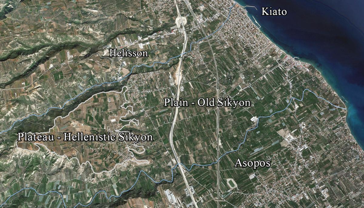
The project targets the Hellenistic plateau city and its immediate hinterland, measuring how the 303 BC refoundation reshaped urban form, land use, and movement between the Asopos and Helisson rivers.
We combine non-invasive survey, geoarchaeology, and targeted excavation to identify the plateau's urban fabric, production zones, and agricultural patterns connected to the plateau edge and surrounding chora.
Primary aims
Wider questions
"How did the refoundation transform plateau settlement patterns, production, and the rural landscape?"
A full-coverage geomagnetic survey with a Bartington Grad601-2 dual fluxgate gradiometer, tied to high-precision GPS. Designed to detect walls, streets, and pits beneath alluvial deposits.
Systematic collection of surface ceramics, coring for geoarchaeology, and distribution mapping to connect urban activity with agricultural land use and erosion signals.
Trenches positioned on clear magnetic anomalies to date structures, test production areas, and apply OSL and pollen analysis for settlement and land use chronology.
Geophysics, ceramics, and geoarchaeology are integrated in a GIS framework to connect urban morphology with environmental change and rural settlement patterns.
Geophysical processing is supported by the Institute for Geosciences at CAU Kiel, ensuring state-of-the-art interpretation and quality control.
Secure Ministry of Culture permits, finalize funding, and assemble the field team and reference group.
Geomagnetic survey, surface collection, and coring on the plateau and its immediate hinterland to map the Hellenistic city and chora.
Targeted excavation based on geophysical anomalies, with OSL and pollen sampling for dating and land use analysis.
Integrated reporting, conservation, and dissemination through a monograph, datasets, and an international seminar.
A structured prototype for a public-facing database. The map layers focus on survey coverage, sample grids, and finds locations. The finds list shows the intended data schema.
Embedded 2D excavation map preview
Sikyon Survey Area
Live 2D excavation map preview
Prototype layers
Core fields
Spatial fields
Find 001
CeramicContext: Trench A3 | Date: 5th-4th c. BC | Lat/Lon: 37.93, 22.75
Notes: Placeholder record for database structure.
Find 002
MetalContext: Grid G12 | Date: Hellenistic | Lat/Lon: 37.94, 22.76
Notes: Placeholder record for database structure.
Find 003
ArchitecturalContext: Survey Block B5 | Date: Roman | Lat/Lon: 37.92, 22.74
Notes: Placeholder record for database structure.
Interested in collaboration or funding opportunities? Contact the project lead.
Dr. Olympia Bobou
Assistant Professor, School of Culture and Society - Unit for East Mediterranean Archaeology, History, and Archival Data